Alaskan Expedition Photos, 5/31/09 - 6/7/09
|
Day 6 - Ideal Cove, Petersburg and Float Plane Flight | |
Day 6, Friday June 5, began with a cruise down Frederick Sound, past Petersburg to Ideal Cove, located on Mitkof Island. After a Zodiac landing, the morning was spent hiking the Three Lakes Trail, a plank-walk trail maintained by the Forest Service. The three-mile hike led to Hill Lake, located in a wet meadowland surrounded by and old-growth forest of spruce and hemlock. | |
After lunch the NG Sea Lion docked at Petersburg for a variety of activities. Petersburg is located at the north end of Mitkof Island, where the Wrangell Narrows meets Frederick Sound. Petersburg is halfway between Juneau, 190 km (120 miles) to the north, and Ketchikan, 180 km (110 miles) to the south. The town was incorporated in 1910 and at the time was populated largely by people of Scandinavian origin thus giving Petersburg the nickname "Little Norway". |
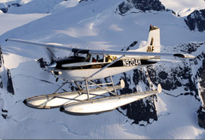 |
We opted to start the afternoon with a float plane tour over the nearby Shakes and LeConte Glaciers and the Stikine River valley and marsh. After the aerial adventure, a short walk covered most of the downtown Petersburg area before heading back to the ship for an Alaskan king crab dinner. | |
Click on an image to see a larger version,
hold cursor on image to see caption
Use arrow icons or
arrow keys to navigate on photo pages.
 |
 |
 |
 |
 |
 |
 |
 |
 |
 |
 |
 |
 |
 |
 |
 |
 |
 |
 |
 |
 |
 |
 |
 |
 |
 |
 |
 |
 |
6-5-09 Daily Expedition Report (PDF file from www.expeditions.com)